ORIGINAL MAP
CREATIONS
Click on the small image to see a larger image of a map,
then use the Back button on your Browser to return to this page.
To purchase a map, just click on the Add to Cart button.
|
Catalog No.
|
Description
|
|
Price
|
|
CAR-MAP-289
|
A Draught
of the Cherokee Country; Henry Timberlake; 1762. A
color recreation of the original map for the Sequoyah Birthplace
Museum; 17" h x 11" w.
|

|
$10
|
|
|
|
|
Catalog No.
|
Description
|
|
Price
|
|
CAR-MAP-290
|
The
Cherokee Lands Included in the Sycamore Shoals Agreement;
Charles A. Reeves, Jr.; Agreement signed 1775. Created for the Sequoyah
Birthplace Museum; 11" h x 16" w.
|

|
$10
|
|
|
|
|
Catalog No.
|
Description
|
|
Price
|
|
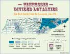
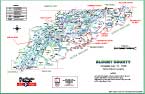
CAR-MAP-026
|
Tennessee-Divided
Loyalties; 17" h x 22" w; created for the East
Tennessee Historical Society exhibit, Four Horsemen: A War Within a
War, Tennessee 1861-1865; shows how each county in the state voted for
secession; Charles A. Reeves, Jr.; 1999.
|
|
$15
|
|
|
|
|
Catalog No.
|
Description
|
|
Price
|
|
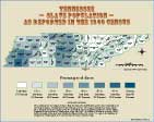
CAR-MAP-080
|
Tennessee
Slave Population As Reported in the 1860 Census;
created from the map, "Map Showing the Distribution of the Slave
Population of the United States - Complied from the Census of 1860"
(see CAR-MAP-078); 17" h x 22" w.
|
|
$15
|
|
|
|
|
Catalog No.
|
Description
|
|
Price
|
|
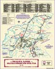
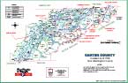
CAR-MAP-027
|
W.R.
Carter, Travels During the Civil War; 17" h x 22" w
created for the East Tennessee Historical Society exhibit, Four
Horsemen: A War Within a War, Tennessee 1861-1865; shows places where
the First Tennessee Calvary traveled during the war; Charles A. Reeves,
Jr.; 1999.
|
|
$15
|
|
|
|
|
Catalog No.
|
Description
|
|
Price
|
|
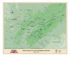
CAR-MAP-028
|
Early
Roads To the Tennessee Country; created for the
First Families of Tennessee History Book from the East Tennessee
Historical Society (ETHS); Charles A. Reeves, Jr.; May, 2000; 17" h x
22" w.
|
|
$15
|
|
|
|
|
Catalog No.
|
Description
|
|
Price
|
|
CAR-MAP-029
|
Sullivan
& Washington Counties [Tennessee], the County Bounds in 1779,
created for the First Families of Tennessee History Book from the East
Tennessee Historical Society (ETHS); Charles A. Reeves, Jr.; May,
2000.; 11" h x 17" w.
|
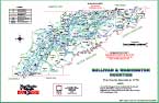
|
$7.20
|
|
|
|
|
Catalog No.
|
Description
|
|
Price
|
|
CAR-MAP-030
|
Davidson
& Greene Counties [Tennessee]. -
Created in 1783, created for the First Families of
Tennessee History Book from the East Tennessee Historical Society
(ETHS); Charles A. Reeves, Jr.; May, 2000.; 11" h x 17" w.
|
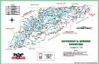
|
$7.20
|
|
|
|
|
Catalog No.
|
Description
|
|
Price
|
|
CAR-MAP-031
|
Hawkins
& Sumner Counties [Tennessee].
- Created in 1786, created for the First Families
of Tennessee History Book from the East Tennessee Historical Society
(ETHS); Charles A. Reeves, Jr.; May, 2000.; 11" h x 17" w.
|
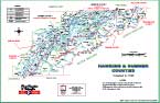
|
$7.20
|
|
|
|
|
Catalog No.
|
Description
|
|
Price
|
|
CAR-MAP-032
|
Knox
& Jefferson Counties [Tennessee] - Created June 11, 1792 from
Greene & Hawkins Counties, created for the
First Families of Tennessee History Book from the East Tennessee
Historical Society (ETHS); Charles A. Reeves, Jr.; May, 2000.; 11" h x
17" w.
|

|
$7.20
|
|
|
|
|
Catalog No.
|
Description
|
|
Price
|
|
CAR-MAP-033
|
Sevier
County [Tennessee] - Created September 27, 1794 from Jefferson County, created
for the First Families of Tennessee History Book from the East
Tennessee Historical Society (ETHS); Charles A. Reeves, Jr.; May,
2000.; 11" h x 17" w.
|
|
$7.20
|
|
|
|
|
Catalog No.
|
Description
|
|
Price
|
|
CAR-MAP-034
|
Blount
County [Tennessee] - Created July 11, 1795 from Knox County, created
for the First Families of Tennessee History Book from the East
Tennessee Historical Society (ETHS); Charles A. Reeves, Jr.; May,
2000.; 11" h x 17" w.
|
|
$7.20
|
|
|
|
|
Catalog No.
|
Description
|
|
Price
|
|
CAR-MAP-035
|
Carter
County [Tennessee] - Created April 1796 from Washington County, created
for the First Families of Tennessee History Book from the East
Tennessee Historical Society (ETHS); Charles A. Reeves, Jr.; May,
2000.; 11" h x 17" w.
|
|
$7.20
|
|
|
|
|
Catalog No.
|
Description
|
|
Price
|
|
CAR-MAP-048
|
The
Counties of the State of Franklin, created for the
First Families of Tennessee History Book from the East Tennessee
Historical Society (ETHS); Charles A. Reeves, Jr.; May, 2000; 11" h x
17" w.
|

|
$7.20
|
|
|
|
|
Catalog No.
|
Description
|
|
Price
|
|
CAR-MAP-036
|
The Road
To Statehood, County Formation in East Tennessee, 1779-1796;
a poster created for the First Families of Tennessee 2000 conference
held by the East Tennessee Historical Society (ETHS); it is a summary
of maps 0029 through 0035 above; Charles A. Reeves, Jr.; May, 2000; 17"
h x 22" w.
|
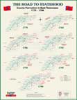
|
$15
|
|
|
|
|
Catalog No.
|
Description
|
|
Price
|
|
CAR-MAP-037
|
Hawkins
County, Territory of Tennessee, County Bounds as they existed in 1790;
created for Billie McNamara from a hand-drawn map located at the H.B.
Stamps Library in Rogersville, TN (original artist unknown); Charles A.
Reeves, Jr.; 1998; 11" h x 17" w.
|
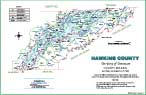
|
$7.20
|
|
|
|
|
Catalog No.
|
Description
|
|
Price
|
|
CAR-MAP-038
|
The
Cherokee County; a copy of a map by Stuart, Hunter,
& Royce in 1937 by J. P. Brown; revised in color by W. F.
Martin in 1999; created for the Sequoyah Birthplace Museum; Charles A.
Reeves, Jr.; 17" h x 22" w.
|

|
$15
|
|
|
|
|
Catalog No.
|
Description
|
|
Price
|
|
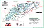
CAR-MAP-106
|
Jackson
County, Tennessee Civil Districts, a map showing
the districts as they were in 1836; 16" h x 21" w.
|

|
$15
|
|
|
|
|
Catalog No.
|
Description
|
|
Price
|
|
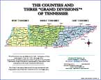
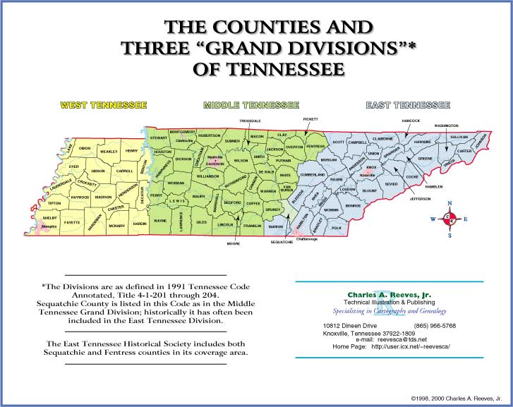
CAR-MAP-039
|
The
Counties and Three "Grand Divisions" of Tennessee;
a map of the state showing all 95 counties and its three grand
divisions (East, Middle, West); Charles A. Reeves, Jr.; 1998; 8" h x
10" w.
|
|
$4
|
|
|
|
|
Catalog No.
|
Description
|
|
Price
|
|
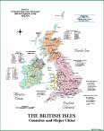
CAR-MAP-068
|
A full color map of the United
Kingdom created for Billie McNamara, showing all
counties and major cities; 17" h x 22" w.
|
|
$15
|
|
|
|
Return
to the Main
Maps page
Return
to the ReevesMaps Home
page.
The entire contents of this page copyright 2000, 2001, 2002,
2006,
2007 Charles A. Reeves, Jr.
This page last updated May 12, 2007.


