(arranged by date of publication)
Click on the small image to see a larger image of a map,
then use the Back button on your Browser to return to this page.
To purchase a map, just click on the Add to Cart button.
A list of maps on this page with links to the maps:
| CAR-MAP-078 - Slave population
in the SE U.S., 1860 |
CAR-MAP-303 - Slave population in the SE U.S., 186? |
| CAR-MAP-074
- Mitchell's Military map of U.S. , 1861 |
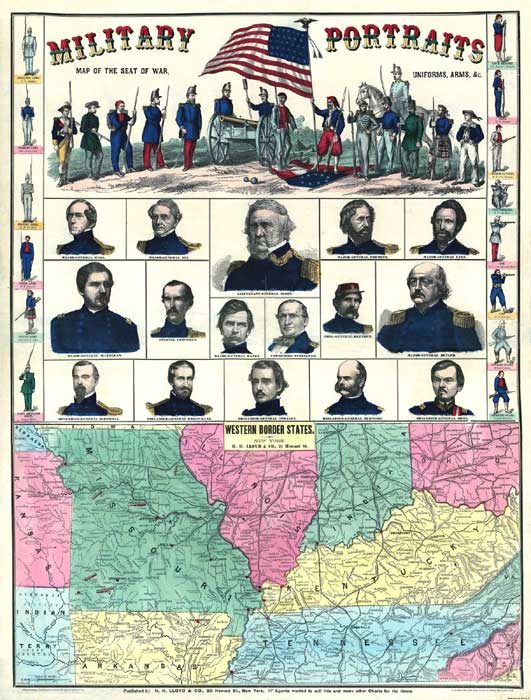
CAR-MAP-134
- Poster, Western Border States, 1861 |
| CAR-MAP-328
- Southeastern U.S., Colton, 1861 |
CAR-MAP-329
- Southern States, Colton, 1861 |
| CAR-MAP-338
- U.S., forts, etc., Colton, 1861 |
CAR-MAP-364
- Eastern U.S., forts, etc., Colton, 1861 |
| CAR-MAP-341
- Southern States, Harper's
Weekly, 1861 |
CAR-MAP-059
- Southern States, Colton, 1861 |
| CAR-MAP-054
- SE U.S., "Seat of War," Perrine, 1862 |
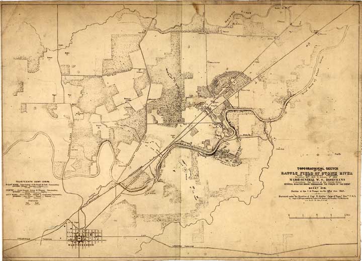
CAR-MAP-291
- Battle of Stone River, Dahl, 1862 |
| CAR-MAP-058
- Asher's Civil War Map, 1862 |
CAR-MAP-058a
- Asher's Civil War Map V2, 1862 |
| CAR-MAP-012
- Eastern U.S. Counties, Magnus, 1862? |
CAR-MAP-135
- Southern States, Wyld, 1862? |
| CAR-MAP-250
- Sumner Co., TN, Blakeslee, 1862 |
CAR-MAP-318
- Military Map of U.S., Bacon, 1862 |
| CAR-MAP-510
- Middle & East TN, Michler, 1862 |
CAR-MAP-530
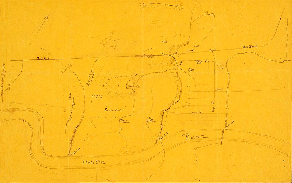
- Fort Sanders, 1863? |
| CAR-MAP-532
- Gettysburg, Bachelder, 1863 |
|
| CAR-MAP-319
- U.S., Bacon, 1863 |
CAR-MAP-216
- Chattanooga Fisheye map, 1863 |
| CAR-MAP-251
- Chattanooga, Blakeslee, 1863 |
CAR-MAP-253
- Fort Sanders, Knoxville, Orth |
| CAR-MAP-256
- Murfreesboro, TN, Michler, 1863? |
CAR-MAP-257
- Murfreesboro, TN, Weyness, 1863 |
| CAR-MAP-258
- Nashville & Vicinity, Blakeslee, 1863 |
CAR-MAP-259
- Nashville, TN, Willet, 186? |
| CAR-MAP-249
- Battlefield of Stone River, Weyss, 1863 |
CAR-MAP-354
- Southern States, Bacon, 1863? |
| CAR-MAP-320
- U.S. Union States, Bacon, 1864 |
CAR-MAP-066
- Southern Military Map, Phelps, etc., 1864 |
| CAR-MAP-115
- Poster, Presidential Campaign, Lloyd, 1864 |
CAR-MAP-218
- Northwest Georgia, Callahan, 1864 |
| CAR-MAP-322
- VA, MD & DE, Colton, 1864 |
CAR-MAP-117
- Southern States, Lloyd, 1865 |
| CAR-MAP-128
- Tennessee River, US Coast Survey, 1865 |
CAR-MAP-347
- N GA, W & Central SC, Lindenkohl, 1865 |
| CAR-MAP-352
- Army of the Cumberland, Ruger, 1865 |
CAR-MAP-357
- W TN & KY, Von Reizenstein, 1865 |
| CAR-MAP-365
- Military Operations of the War, Colton, 1867 |
CAR-MAP-361
- U.S. Military map, Bein, 1869 |
| CAR-MAP-212
- Middle TN & East TN, Mergell, 1874 |
CAR-MAP-217
- Battlefield of Chattanooga, Smith, 1875 |
| CAR-MAP-119
- US RR & County map, Rand-McNally, 1876 |
CAR-MAP-252
- Cumberland Gap, Ruger, 1877 |
| CAR-MAP-376
- Atlanta Campaign, Fleming, 1887 |
CAR-MAP-096
- Battles of Chattanooga & Chickamauga |
| CAR-MAP-109
- The Atlanta Campaign (6 maps) |
CAR-MAP-109a - The Atlanta Campaign, Overview |
| CAR-MAP-109c - The Atlanta Campaign, Epoch 1 | CAR-MAP-109e - The Atlanta Campaign, Epoch 2 |
| CAR-MAP-109g - The Atlanta Campaign, Epoch 3 | CAR-MAP-109i - The Atlanta Campaign, Epoch 4 |
| CAR-MAP-109k - The Atlanta Campaign, Epoch 5 | CAR-MAP-148
- Booklet, Chattanooga, U.S. Grant, 1885 |
| CAR-MAP-164
- The Siege of Knoxville, Poe, 1895 |
CAR-MAP-164a - The Siege of Knoxville, Poe, 1895 with modern roads |
| CAR-MAP-165 - Army of the Cumberland, 1895 | |
| CAR-MAP-314
- SE U.S. Atlas maps, 1895 (15 maps) |
CAR-MAP-314n - SE U.S. Atlas maps, sheet 1, 1895 |
| CAR-MAP-314o - SE U.S. Atlas maps, sheet 2, 1895 | CAR-MAP-314a - SE U.S. Atlas maps, sheet 3, 1895 |
| CAR-MAP-314b - SE U.S. Atlas maps, sheet 4, 1895 | CAR-MAP-314c - SE U.S. Atlas maps, sheet 5, 1895 |
| CAR-MAP-314d - SE U.S. Atlas maps, sheet 6, 1895 | CAR-MAP-314e - SE U.S. Atlas maps, sheet 7, 1895 |
| CAR-MAP-314f - SE U.S. Atlas maps, sheet 8, 1895 | CAR-MAP-314g - SE U.S. Atlas maps, sheet 9, 1895 |
| CAR-MAP-314h - SE U.S. Atlas maps, sheet 10, 1895 | CAR-MAP-314i - SE U.S. Atlas maps, sheet 11, 1895 |
| CAR-MAP-314j - SE U.S. Atlas maps, sheet 12, 1895 | CAR-MAP-314k - SE U.S. Atlas maps, sheet 13, 1895 |
| CAR-MAP-314l - SE U.S. Atlas maps, sheet 14, 1895 | CAR-MAP-314m - SE U.S. Atlas maps, sheet 15, 1895 |
| CAR-MAP-215
- Battle of Chattanooga, 1901 |
CAR-MAP-073
- Poster, Confederate states (2 sheets), 1910 |
| CAR-MAP-214
- Chattanooga panoramic, 1913 |
CAR-MAP-147
- Chicamauga (2 sheets), 1898 |
| CAR-MAP-125
- Southeastern states, Rand-McNally, 1923 |
CAR-MAP-509
- O.O. Howard's march to Knoxville 1863 |
| CAR-MAP-573
- Seige of Knoxville 2019 |
Mitchell's Military Map of
the United States; 1861; 24" h x 26" w Colton's Map of Eastern North
Carolina, Virgina & South Carolina;
from a copy at the Library of Congress Archives;
1861; 40" x 28" Colton's Map of the Southern
States; from a copy at the Library of
Congress Archives; 1861; 37" x 53" Colton's Map of the United
States shewing the military stations, forts
&c; from a copy at the Library of
Congress Archives; 1861; 17" x 27" Map of the Southern States;
Harper's Weekly; from a copy at the Library
of Congress Archives; 1861; 18" x 29" Topographical Sketch of the
Battlefield of Stone River; O. R.
Dahl; 1862. Created from a print at the Library of
Congress Archives; 15" h x 21" w From Mitchelsville [sic] to
Gallatin--Sumner Co. Tenn.; G. H.
Blakeslee; from a copy at the Library of Congress
Archives; 1862; 15" x 20" Bacon's Military Mao of the
United States shewing the forts &
fortifications; from a copy at the
Library of Congress Archives; 1862; 15" x 26" Map of Middle & East
Tennessee, including parts of Alabama &
Georgia; from a copy at the Library of
Congress Archives; 1862; 42" x 64" Map of Fort Sanders at the
time of battle; from the Harvard
Digital Library; 1863?; 13" x 20" Map of Gettysburg, July 1, 2
& 3, 1863; Bachelder; from the
Library of Congress Archives; 36" x 24" Bacon's Steel Plate Map of
America, political, historical & military;
Bacon & Co.; from a copy at the Library of
Congress Archives; 1863; 22" x 34" Fisheye view of Chattanooga
and vicinity showing troop positions in 1863;
from a copy at the Library of Congress Archives;
1863; 17" x 15" Chattanooga Tenn 1863;
two maps by G.H. Blakeslee; from a copy at the
Library of Congress Archives; 18623; 22" x 16" Map of Fort Sanders,
Knoxville, Tennessee; John G. Orth;
from a copy at the Library of Congress Archives;
1863; 17" x 22" Plat of Murfreesboro
[Tennessee]; N. Michler; from a copy
at the Library of Congress Archives; 1863?; 15" x
20" Topographical Sketch of the
Environs of Murfreesboro, Tennessee;
John E. Weyness; from a copy at the Library of
Congress Archives; 1863; 19" x 19" Nashville and Vicinity;
G.H. Blakeslee; from a copy at the Library of
Congress Archives; 1863; 15" x 20" Topography of Nashville,
Tenn.; James R. Willet; from a copy at
the Library of Congress Archives; 186?; 11" x 14" Map of the Southern
States...; Bacon & Co.; from a
copy at the Library of Congress Archives; 1863?;
20" x 30" Northwestern Georgia;
Denis Callahan; from a copy at the Library of
Congress Archives; 1864; 38" x 34" Colton's new topographical
map of the states of Virginia, Maryland and
Delaware...; from a copy at the
Library of Congress Archives; 1864; 32" x 45" Map of the Tennessee River
for the use of the Mississippi Squadron Under
command of Acting Rear Admiral S.P. Lee,
U.S.N; U.S. Coast Survey; a
spiral-bound booklet of 17 maps detailing
approximately one mile on either side of the river
from Paducah, KY to Muscle Shoals, AL; includes
landowner names and index; created from a print at the Library of
Congress Archives; 1865; 11" h x 13" w, printed
11" x 17 A Typical Map Northern Georgia and Western
& Central South Carolina; A.
Lindenkohl; from a copy at the Library of Congress
Archives; 1865; 23" x 34" Campaigns of the Army of the
Cumberland; E. Ruger; from a copy at
the Library of Congress Archives; 1865; 27" x 32" Western Tennessee and Part of
Kentucky; B. Von Reizenstein; from a
copy at the Library of Congress Archives; 1865;
16" x 26" Military map of the United
States; Julius Bein; from an original
copy; 1869; 42" x 30" Military Map of Middle
Tennessee & Parts of East Tennessee;
C. S. Mergell; from a copy at the Library of
Congress Archives; 1874; 36" x 55" Map of the Batttlefield of
Chattanooga; William F. Smith; from a
copy at the Library of Congress Archives; 1875;
29" x 22" Operations of the Seventh
Division...at Cumberland Gap, Tennessee...;
E. Ruger; from a copy at the Library of Congress
Archives; 1877; 16" x 20" A Map of the Atlanta
Campaign, Western & Atlantic Rairoad;
Brewster Fleming, 1887. Created from a print at
the Library of Congress Archives; 32" x 17" An overview of the area covered by
the five epoch maps Epoch One Map - Tennessee
River to Oostanaula River; 35" x 21" Epoch II Map - Resaca to
Ackworth; 28" x 25" Epoch III Map - Rome,
Kingston and Cassville to Dallas and Marietta; 23"
x 32" Epoch IV Map - Pine, Lost
and Kennesaw Mountains to Atlanta; 25" x 26" Epoch V Map - Chattahoochee
River to Jonesboro and Lovejoy's Station; 26" x
26" The Siege of Knoxville,
Created from an original copy of a map in the Atlas
to Accompany the Official Records of the Union
and Confederate Armies; 1891-1895; 17" h x
22" w (slightly larger than the original). Notes: This is the version with modern-day
roads overlaid Also see CAR-MAP-573, a newer
creation with more information. General Topographical Maps of
the Theater of War; Sheet 1 - South
PA, East WV, MD & DE; 30" x 19" General Topographical Maps of
the Theater of War; Sheet 2 - South
WV, North VA, South MD & DE; 30" x 19" General Topographical Maps of
the Theater of War; Sheet 3 - East NC
& VA; 30" x 19" General Topographical Maps of
the Theater of War; Sheet 4 - East NC
& SC; 30" x 19" General Topographical Maps of
the Theater of War; Sheet 5 - Ohio, WV
& PA; 30" x 19" General Topographical Maps of
the Theater of War; Sheet 6 - East KY,
VA & WV; 30" x 19" General Topographical Maps of
the Theater of War; Sheet 7 - East TN
& Western NC; 30" x 19" General Topographical Maps of
the Theater of War; Sheet 8 - North GA
& West SC; 30" x 19" General Topographical Maps of
the Theater of War; Sheet 9 - Central
GA & West SC; 30" x 19" General Topographical Maps of
the Theater of War; Sheet 10 - East GA
& North FL; 30" x 19" General Topographical Maps of
the Theater of War; Sheet 11 - Central
& South FL; 30" x 19" General Topographical Maps of
the Theater of War; Sheet 12 -South AL
& West FL; 30" x 19" General Topographical Maps of
the Theater of War; Sheet 13 - Central
AL & GA; 30" x 19" General Topographical Maps of
the Theater of War; Sheet 14 -South
TN, North AL & GA; 30" x 19" General Topographical Maps of
the Theater of War; Sheet 15 - South
KY & North TN; 30" x 19" Map of the Battlefields of
Chattanooga; created from a print at
the Library of Congress Archives; 1901; 17" x 22" Chattanooga and Surrounding
Battlefields; Reginald Purse; created
from a print at the Library of Congress Archives;
1913; 9" x 20"


Return to the Main Maps page