then use the Back button on your Browser to return to this page.
To purchase a book or map, just click on the Add to Cart button.
|
|
The Full Atlas; A loose leaf bound, full color paperback book containing all 25 pages, approximately 11" x 17". |
 |
|
|
|
|
Book Cover, approximately 8x10. |
|
|
|
|
|
Book Index, approximately 8x10. |
 |
|
|
|
|
County Statistics, approximately 8x10. |
 |
|
|
|
|
Map of the United States, approximately 11x17. |
 |
|
|
|
|
Map of Kentucky, approximately 11x17. |
 |
|
|
|
|
Map of Bourbon, Clark, Fayette, Jessamine & Woodford Counties, approximately 8x10. |
 |
|
|
|
|
Part of Bourbon Co., Precincts 2, 7, 8 & Part of 1, approximately 11x17. |

|
|
|
|
|
Part of Bourbon Co., Precincts 3, 4, 5, 6 & Part of 1, approximately 11x17. |
 |
|
|
|
|
The town of Paris, Bourbon Co., approximately 11x17. |
 |
|
|
|
|
The towns of Ruddels Mills, North Middletown, Clintonville and Flat Rock, Bourbon Co., approximately 8x10. |
 |
|
|
|
|
The Town of Millersburg, Bourbon Co., approximately 8x10. |
 |
|
|
|
|
Part of Clark Co., Precincts 3, 4 & 6, approximately 11x17. |
 |
|
|
|
|
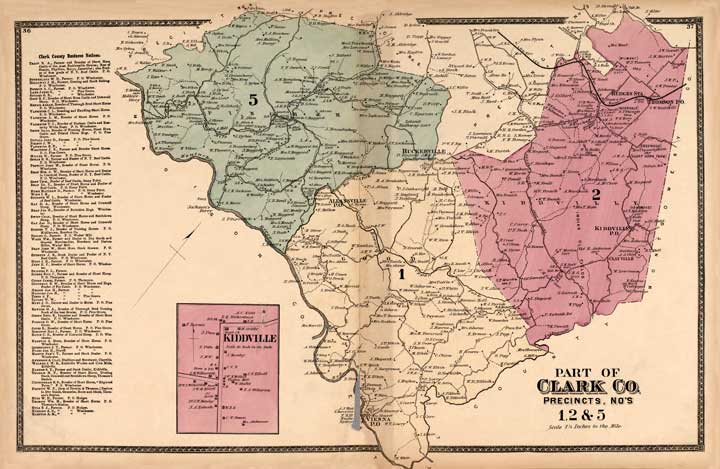
Part of Clark Co., Precincts 1, 2 &5, approximately 11x17. |
 |
|
|
|
|
The town of Winchester, Clark Co., approximately 11x17. |
 |
|
|
|
|
Part of Lexington, 2nd and 3rd Wards, Fayette Co., approximately 11x17. |
 |
|
|
|
|
Part of Lexington, 1st and 4th Wards, Fayette Co., approximately 11x17. |
 |
|
|
|
|
Part of Fayette Co, Precincts 3, 4 &5, approximately 11x17. |
 |
|
|
|
|
Part of Fayette Co, Precincts 1, 2 & 6., approximately 11x17. |
 |
|
|
|
|
Part of Jessamine Co., Precincts 1, 4 &4, plus the towns of Keene and Athens, approximately 11x17. |
 |
|
|
|
|
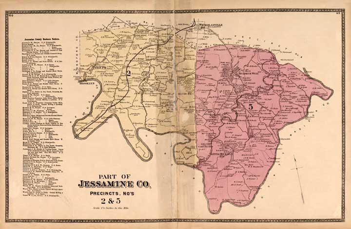
Part of Jesssamine Co., Precincts 2 & 5, approximately 11x17. |
 |
|
|
|
|
The town of Nicholasville, Jessamine Co., approximately 11x17. |
 |
|
|
|
|
Part of Woodford Co., Precincts 2, 3 & 6, approximately 11x17. |
 |
|
|
|
|
Part of Woodford Co., Precincts 4 & 5, approximately 8x10. |
 |
|
|
|
|
Part of Woodford Co., Precinct 1, plus the town of Midway, Woodford Co., approximately 8x10. |
 |
|
|
|
|
The town of Versailles, Woodford Co., approximately 8x10. |
 |
|
|