MAPS OF THE WORLD AND WORLD CITIES
(arranged by location and date of publication)
Also see other maps of the world in the Atlases section.
Click on the small image to see a larger image of a map,
then use the Back button on your Browser to return to this page.
To purchase a map, just click on the Add to Cart button.
A list of the maps in this section with links to the maps:
| CAR-MAP-308 - World, Waldseemuller, 1507 |
CAR-MAP-093
- World (Portuguese), Forlani, 1565 |
| CAR-MAP-307
- World, Sype, 1581 |
CAR-MAP-348
- World, Hondius, 1565 |
| CAR-MAP-453
- World, Blaeu, 1606 |
CAR-MAP-245
- Americas, Blaeu, 1645 |
| CAR-MAP-244
- Nova Totius Terrarum... (World), Colon, 1650 |
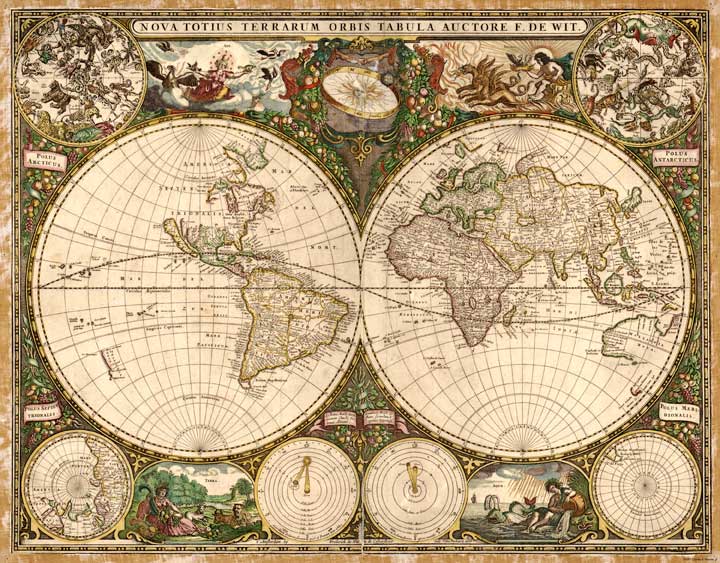
CAR-MAP-456
- World, de Wit, 1660 |
| CAR-MAP-463
- Africa, Blaeu, 166? |
CAR-MAP-081
- Nova et accuratissima... (World), Holland, 1664? |
| CAR-MAP-185
- Mediterranean Sea, Berry, 1685 |
CAR-MAP-455
- World, de L'Isle, 1690? |
| CAR-MAP-186
- Mediterranean Sea, Valck, 1695 |
CAR-MAP-457
- World, Nolin, 1708 |
| CAR-MAP-094
- Planiglobii terrestris... (World), Homann, 1716 |
CAR-MAP-514 - World, Charlelain, 1719 |
| CAR-MAP-454 - World, de L'Isle, 1720 | CAR-MAP-095 - World, Moll, 1732 |
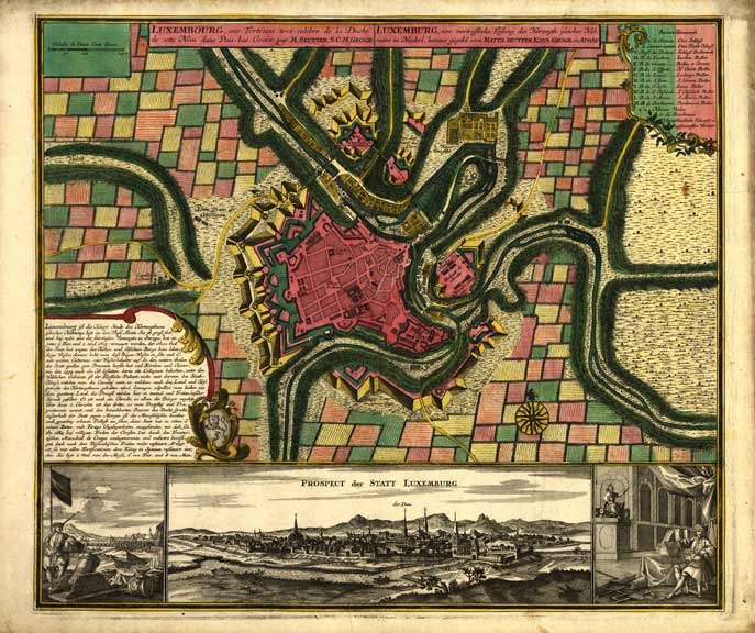
| CAR-MAP-451 - Luxembourg, Homann, 17?? | CAR-MAP-452 - Luxembourg, Seutter, 173? |
| CAR-MAP-295 - Europe, Senex, 1740 | CAR-MAP-184 - Northern Africa, Elwe, 1742 |
| CAR-MAP-219 - Empire of Germany, Delarochette, 1782 | CAR-MAP-092 - World, Carey, 1795 |
| CAR-MAP-517,
Europe, Carey, 1804 |
CAR-MAP-438
- World, Laurie & Whittle, 1808 |
| CAR-MAP-459
- Brazil, Carey, 1814 |
CAR-MAP-208
- England, SDUK, 1837 |
| CAR-MAP-437
- British Empire throughwout the World, Bartholomew, 185? |
CAR-MAP-246
- Environs of Paris, Colton, 1855 |
| CAR-MAP-247
- Environs of London, Colton, 1855 |
CAR-MAP-325
- Japan, etc., Colton, 1854 |
| CAR-MAP-431
- Nicarauga, Haven, 1856 |
CAR-MAP-288
- Route of Dr. Livingston in Africa, Arrowsmith, 1857 |
| CAR-MAP-229
- North & South Wales, McFarlane, 1859 |
CAR-MAP-223
- Africa, Mitchell, 1860 |
| CAR-MAP-226
- Africa, Johnson, 1865 |
CAR-MAP-324
- Europe, Colton, 1870 |
| CAR-MAP-435
- Brazil, Paraguay, Uruguay & Chile, Mitchell, 1871 |
CAR-MAP-098
- Paris, France, source & date unknown |
| CAR-MAP-149
- Paris, France, Britannica, 1888 |
CAR-MAP-173
- England & Wales, Mitchell, 1890 |
| CAR-MAP-300
- Italy, Scribner, 1890 |
CAR-MAP-426
- World, Century Atlas, 1902 |
| CAR-MAP-427
- Chinese Empire, Century Atlas, 1902 |
CAR-MAP-460
- Souvenir Map of WWI - Stiles, 1932 |
A Map of the World--Martin
Waldseemuller published in 1507. Created from a print at the Library of
Congress Archives; 42" h x 76" w. A Map of the World--Nicola van
Sype; published in 1581. Created from a print at the Library of
Congress Archives; 12" h x 21" w. Map of the World--Hondius; 1565.
Created from a print at the Library of Congress Archives; 16" h x 22" w. A Map of the Americas--A map of
North and South America by Williem Blaeu, Amsterdam published in 1645.
Created from a copy in an old book; 15" h x 20" w. Map of the World; Frederik de.
Wit; 1660; Created from a print at the Library of Congress Archives;
18" x 24" Africa; William Blaeu, Amsterdam
published in 166?; Created from a print at the Library of Congress
Archives; 17" x22" The Mediterranean Sea; Berry;
1685; Created from a print at the Library of Congress Archives; 21" h x
34" w. Map of the World; Guillaume de
L'Isle; 1690?; Created from a print at the Library of Congress
Archives; 20" x 28" The Mediterranean Sea; Valck;
1695; Created from a print at the Library of Congress Archives; 18" h x
45" w. Map of the World; Jean Baptiste
Nolin; 1708; Created from a print at the Library of Congress Archives;
original size 47" x 60" printed 42" x 55" Carte tres curieuse de la Mer...;
A map of the
world by Henri Abraham Chatelain; 1719; Created from a print at the
Boston Public Library; 40" h x 23" w. Map of the World; Guillaume de
L'Isle; 1720; Created from a print at the Library of Congress Archives;
17" x 22" Ducatus Luxemburgi (Luxembourg);
Johannj Baptist Homann; 17--; Created from a print at the Library of
Congress Archives; 17" x 22" Luxembourg; Matthaeus Seutter; 173?;
Created from a print at the Library of Congress Archives; 17" x 22" Europe; John Senex 1740. Created
from a print at the Library of Congress Archives; 25" h x 37" w. Northern Africa; Elwe; 1742;
Created from a print at the Library of Congress Archives; 19" h x 22" w. Map of the Empire of Germany-;
L. Delarochette; 1782. Created from a print at the Library of Congress
Archives; two sheets, 20" h x 47" w. A New Map of Europe; by John
Carey, published in 1804;
Created from an original copy; 18" h x 20" w. The World; Laurie & Whittle;
1808; Created from a print at the Library of Congress Archives; 16" x
24" Brazil; Mathew Carey; 1814;
Created from a print at the Library of Congress Archives; 17" x 22" British Empire Throughout the World;
John Bartholomew; 185?. Created from a print at the Library of Congress
Archives; 17" x 22" The Environs of Paris--From General
Atlas by John H. Colton; 1855; from an original copy; 16" h x 20" w. The Environs of London--From General
Atlas by John H. Colton; 1855; from an original copy; 15" h x 18" w. Colton's Japan: Nippon, Kiusiu, Sikok,
Yesso and the Japanese Kuriles; 1854. Created from a copy at
the Library of Congress Archives; 16" h x 19" w. Nicarauga; John Haven; 1856.
Created from a copy at the Library of Congress Archives; 32" x 26" The Route of Dr. Livingston in Africa--Arrowsmith;
published in 1857. Created from an original copy; 17" h x 22" w. North and South Wales; W. H.
McFarlane; 1859. Created from an original copy; 19" h x 27" w. Africa; S.A. Mitchell; 1860.
Created from an original copy; 17" h x 22" w. Africa; A. J. Johnson; 1865.
Created from an original copy; 20" h x 27" w. A Map of Europe; Colton; 1870.
Created from an original copy; 33" h x 26" w. Brazil, Paraguay, Uruguay & Part of
Chile; Mitchell; 1871. Created from an original copy; 17" x 22" A Map of the City of Paris, France;
Source and date unknown; 28" h x 34" w. A Map of Paris, France. From
Encyclopedia Britannica, Ninth Edition, 1888; 15" h. x 20" w, twice the
size of the original. England and Wales; Augustus
Mitchell; 1890; Created from an original copy; 17" h x 22" w. Italy; Charles Scribner's Sons;
created from a print at the Library of Congress Archives; 1890; 16" h x
21" w. World; The Century Atlas.; 1902.
Created from an original copy, 24" h x 32" w. Note: I have a complete copy of this atlas
and can provide copies of any of its beautiful maps. Contact me for
further details. Chinese Empire; The Century
Atlas.; 1902. Created from an original copy, 17" x 22" Note: I have a complete copy of this atlas
and can provide copies of any of its beautiful maps. Contact me for
further details.