ANTIQUE MAP REPRODUCTIONS
EARLY MAPS OF TENNESSEE & SURROUNDING AREA
(arranged by date of publication)
Also see other maps of Tennessee in the Atlases
section
and 1930s county maps in the Postal Routes
section.
Click on the small image to see a larger image of a map,
then use the Back button on your Browser to return to this
page.
To purchase a map, just click on the Add to Cart button.
A list of maps on this page with links to the maps:
| CAR-MAP-051 - Carolina,
Moll, 1732 |
CAR-MAP-362 - Aboriginal
Map of Tennessee, Goodspeed, before 1790s |
| CAR-MAP-122 - A Map of
Kentucke, Filson, 1784 |
CAR-MAP-001 - A Map of the
Tennessee Government; Smith & Reid, 1795 |
| CAR-MAP-264 - Cumberland
and Franklin (Tennessee), Ramsey, 1784 |
CAR-MAP-582 - A Map
of Tennessee, Morse, 1794
|
| CAR-MAP-275
- Kentucky, Melish, 1795 |
CAR-MAP-278
- Kentucky with adjoining territories, Reid,
1795 |
| CAR-MAP-274
- The Falls of the Ohio [River], Melish, 1795
|
CAR-MAP-280
- Kentucky, Scott, 1795 |
| CAR-MAP-243
- Tennessee and Kentucky, 1796, Morse |
CAR-MAP-279
- Kentucky with adjoining territories, Scoles,
1800 |
| CAR-MAP-242
- Tennessee, 1804, Arrowsmith & Lewis
|
CAR-MAP-273
- Kentucky, Lewis, 1805 |
| CAR-MAP-159
- Tennessee as it was in 1795, Carey, 1814 |
CAR-MAP-254
- Tennessee as it was in 1795, Lewis, 1817 |
| CAR-MAP-494 - Tennessee, to
1799, Lee |
CAR-MAP-495
- Kentucky, to 1799, Lee |
| CAR-MAP-496
- The Ohio Country & the Northwest
Territory, to 1799, Lee |
CAR-MAP-480
- Tennessee, Melish, 1818 |
| CAR-MAP-272
- Kentucky and Tennessee, Jocelyn, 1825 |
CAR-MAP-255
- Tennessee, Lucas, 1826 |
| CAR-MAP-140
- Southern United States [Georgia], 1833 |
CAR-MAP-487
- Tennessee, Matthew Rhea, 1825 |
| CAR-MAP-487b
- Tennessee, Matthew Rhea, half size, 1825
|
CAR-MAP-516
- KY-TN Sears, 1834 |
| CAR-MAP-002 -
Tennessee, Bradford, 1837
|
CAR-MAP-505 -
KY & TN, Bradford, 1835 |
| CAR-MAP-515 -
Hawkins Co. Civil Districts, 1836 |
CAR-MAP-107
- Southern States, 1838 |
| CAR-MAP-224 -
Kentucky and Tennessee, Morse &
Breese, 1845
|
CAR-MAP-579 - Map of
the Plan of Knoxville, TN, Lea |
| CAR-MAP-069
- Tennessee, Cowperthwait/Mitchell, 1855 |
CAR-MAP-152
- Tennessee, Colton, 1855 |
| CAR-MAP-358
- Nashville, 1855 |
CAR-MAP-531
- Memphis Rucker, 1858 |
| CAR-MAP-227
- Sketch of the Cherokee Country, Bancroft,
1860 |
CAR-MAP-261
- Nashville, Poe, 1860s |
| CAR-MAP-537
- Nashville, Hayden & Booth, 1860 |
CAR-MAP-097 -
Kentucky & Tennessee, Campbell &
Barlow, 1861 |
| CAR-MAP-518
- Southeast TN, 1863 |
CAR-MAP-004
- Kentucky & Tennessee, Mitchell, 1863 |
| CAR-MAP-213
- Tennessee, Lloyd, 1862 |
CAR-MAP-007
- Mountain Region of NC and TN, Reid, 1864 |
| CAR-MAP-006
- Kentucky & Tennessee, Johnson, 1865 |
CAR-MAP-131
- Geological Map of Tennessee, 1866 |
| CAR-MAP-005
- Tennessee, Reeves, 1867 |
CAR-MAP-313
- Tennessee Geological & Agricultural,
Killebrew, 1874 |
| CAR-MAP-236
- Davidson County, TN, Foster, 1871 |
CAR-MAP-489
- Nashville, Foster, 1879 |
| CAR-MAP-154
- Kentucky & Tennessee, Gray, 1873 |
CAR-MAP-284
- Kentucky & Tennessee, Asher & Adams,
1873 |
| CAR-MAP-234
- Montgomery County Property Owners, Beers,
1877 |
CAR-MAP-502
- Madison County Property Owners, Beers, 1877 |
| CAR-MAP-503
- Gibson County Property Owners, Beers, 1877
|
CAR-MAP-528 -
Haywood County Property Owners, Beers, 1877 |
| CAR-MAP-500
- Sumner County Property Owners, Beers 1878 |
CAR-MAP-111
- Bedford County Property Owners, Beers, 1878 |
| CAR-MAP-479
- Maury County Property Owners, Beers, 1878 |
CAR-MAP-233
- Rutherford County Property Owners, Beers,
1878 |
| CAR-MAP-511 -
Williamson County Property Owners, Beers, 1878
|
CAR-MAP-571d -
TN/KY map and indexes, McNally Business Atlas,
1879 |
| CAR-MAP-112 -
Bedford County Civil Districts, 1835
|
CAR-MAP-113 -
Bedford County Civil Districts |
| CAR-MAP-008 -
Former territorial limits of the
Cherokee, Royce, 1884 |
CAR-MAP-543 -
Knoxville, from City Directory, 1887 |
| CAR-MAP-501
- Shelby County Property Owners,
Williamson, 1888
|
CAR-MAP-014
- Tennessee Railroad & County map,
Rand, McNally, 1888 |
| CAR-MAP-263 -
Chattanooga, Hopkins, 1890 |
CAR-MAP-239 -
Knoxville, Sanborn, 1890 |
| CAR-MAP-150 -
Kentucky & Tennessee, Cram, 1891 |
CAR-MAP-572 -
Harriman, TN 1892 |
| CAR-MAP-137
- Memphis, Cram, 1894
|
CAR-MAP-138
- Nashville, Cram, 1894 |
| CAR-MAP-240
- Knoxville, Ogden Brothers, 1895 |
CAR-MAP-171
- Knox County Property Owners, 1895 |
| CAR-MAP-482
- Lonsdale, Knox County, TN |
CAR-MAP-527
- Nashville, 1896 |
| CAR-MAP-538 -
Nashville, Matthews-Northrup, 1897
|
CAR-MAP-580
- Knoxville, Crozier 1987
|
| CAR-MAP-163-54 - Indian
Cession Map, TN, 1897 |
CAR-MAP-163-55 - Indian
Cession Map, Middle TN, 1897 |
| CAR-MAP-163-56
- Indian Cession Map, West TN, 1897 |
CAR-MAP-498
- Marshall County Property Owners, 1899 |
| CAR-MAP-499 - Davidson
County, 1900 |
CAR-MAP-160 - The Cherokee
Country, 1900 |
CAR-MAP-536
- Kentucky & Tennessee, early 1900s, Waite
|
CAR-MAP-153 - Tennessee,
New Century Atlas, 1897-1902 |
| CAR-MAP-139 - Kentucky
& Tennessee, Peerless Atlas, 1908 |
CAR-MAP-241 - Knoxville,
1917, Sanborn |
| CAR-MAP-540 - Davidson
County, 1920 |
CAR-MAP-222a - Tennessee
roadways, Rand, McNally, 1920 |
| CAR-MAP-222b
- Tennessee railroads, Rand, McNally, 1920 |
CAR-MAP-177
- Archaeological Map of Tennessee, 1924-25 |
| CAR-MAP-497 - Knoxville,
Nirenstein, 1929 |
CAR-MAP-298 - Proposed
Great Smoky Mountains National Park, 1926 |
CAR-MAP-541 - Roane
County, TN, approx. 1930
|
CAR-MAP-299 - Preliminary
Base Map, Great Smoky Mountains NP, 1934 |
| CAR-MAP-488a
- Great Smoky Mountains National Park, East, 1934 |
CAR-MAP-488b
- Great Smoky Mountains National Park, West, 1934 |
CAR-MAP-542
- Smith County, TN, 1937
|
CAR-MAP-539
- Clay County, TN, 1938 |
| CAR-MAP-312 - Tennessee
& its major cities, WPA, 1939 |
CAR-MAP-312a -
Tennessee, 1939 |
| CAR-MAP-312b - Tennessee,
major cities, 1939 |
CAR-MAP-312c -
Chattanooga, 1939 |
| CAR-MAP-312k - Knoxville,
1939 |
CAR-MAP-312m - Memphis,
1939 |
| CAR-MAP-312n - Nashville,
1939 |
CAR-MAP-581
- Douglas Dam Cemetery Relocation - 1941
|
| CAR-MAP-523
- Clinton, 1943 |
CAR-MAP-506
- Oak Ridge, 1946 |
| CAR-MAP-105 -
Knoxville, 1948 |
|
|
Catalog No.
|
Description
|
|
Price
|
|
CAR-MAP-051
|
Carolina; published
by Herman Moll; 1732. Created from a print at the
Library of Congress Archives;
17" h x 22" w
|

|
$15
|
|
|
|
|
Catalog No.
|
Description
|
|
Price
|
|
CAR-MAP-362
|
Aboriginal Map of Tennessee,
Published by Goodspeed Publishing in
1886, but represents the state as it was before
the state was formed; 21" x 10"
|

|
$15
|
|
|
|
|
Catalog No.
|
Description
|
|
Price
|
|
CAR-MAP-122
|
A Map of Kentucke [sic];
a very early map drawn by John Filson; 1784.
Published by T. Rook, Philadelphia. Created from a
print at the Library of Congress Archives; 20" h x
18" w
|

|
$15
|
|
|
|
|
Catalog No.
|
Description
|
|
Price
|
|
CAR-MAP-001
|
A Map of the Tennessee
Government, Formerly Part of North Carolina,
taken Chiefly from Surveys by Gen. D. Smith
& others; a large map; John Reid,
publisher.; From Matthew Carey's American Atlas,
1795. Created from a print at the Library of
Congress Archives; 16" h x 36" w
|

|
$24
|
|
|
|
|
Catalog No.
|
Description
|
|
Price
|
|
CAR-MAP-264
|
A Map of Cumberland and
Franklin [Tennessee], from the Annals
of Tennessee by Dr. J.G. M. Ramsey,
published in 1852, but represents the state as it
was ca 1784; 21" x 10" somewhat larger than the
original.
|

|
$15
|
|
|
|
|
Catalog No.
|
Description
|
|
Price
|
|
CAR-MAP-582
|
A Map of Tennessee,
by Dr. Jedidiah Morse, 1794; 8" x 10" slightly
larger than the original. It may have provided
input for the Smith map above.
|

|
$5
|
|
|
|
|
Catalog No.
|
Description
|
|
Price
|
|
CAR-MAP-275
|
Kentucky; John
Melish; 1795. Created from a print at the Library
of Congress Archives; 12" h x 21" w.
|

|
$15
|
|
|
|
|
Catalog No.
|
Description
|
|
Price
|
|
CAR-MAP-278
|
Map of the State of Kentucky,
with Adjoining Territories; John Reid;
1795. Created from a print at the Library of
Congress Archives; 15" h x 17" w.
|

|
$15
|
|
|
|
|
Catalog No.
|
Description
|
|
Price
|
|
CAR-MAP-274
|
The Falls of the Ohio
[River]; John Melish; 1795. Created
from an original copy; 7" h x 70" w, about twice
the size of the original.
|

|
$7.50
|
|
|
|
|
Catalog No.
|
Description
|
|
Price
|
|
CAR-MAP-280
|
Kentucky; Joseph
Scott; 1795. Created from a print at the Library
of Congress Archives; 16" h x 17" w..
|

|
$15
|
|
|
|
|
Catalog No.
|
Description
|
|
Price
|
|
CAR-MAP-243
|
Map of Tennessee and
Kentucky, 1796; a reproduction of a
map from the American Universal Geography by
Jedidiah Morse, 14" x 21" approximately twice the
size of the original.
|

|
$15
|
|
|
|
|
Catalog No.
|
Description
|
|
Price
|
|
CAR-MAP-279
|
Map of the State of Kentucky,
with Adjoining Territories; John
Scoles; 1800. Created from a print at the Library
of Congress Archives; 16" h x 19" w...
|

|
$15
|
|
|
|
|
Catalog No.
|
Description
|
|
Price
|
|
CAR-MAP-242
|
Map of Tennessee, 1804;
a reproduction of a map by Arrowsmith and Lewis,
from their General Atlas, from an original copy,
16" x 20" (approximately twice the size of the
original)
|

|
$15
|
|
|
|
|
Catalog No.
|
Description
|
|
Price
|
|
CAR-MAP-273
|
Kentucky; Samuel
Lewis; 1805. Created from a print at the Library
of Congress Archives;17" h x 22" w.
|

|
$15
|
|
|
|
|
Catalog No.
|
Description
|
|
Price
|
|
CAR-MAP-159
|
The State of Tennessee as it
was in 1795; published by Mathew
Carey; 1814. Created from an original copy; 17" h
x 22" w (slightly larger than the original).
|

|
$15
|
|
|
|
|
Catalog No.
|
Description
|
|
Price
|
|
CAR-MAP-254
|
The State of Tennessee as it
was in 1795; from the Samuel Lewis
Atlas; 1817. Created from a print at the Library
of Congress Archives; very similar to CAR-MAP-159
but with more intense colors; 9" h x 20" w.
|

|
$15
|
|
|
|
|
Catalog No.
|
Description
|
|
Price
|
|
CAR-MAP-494
|
A General Map of The State of
Tennessee - to 1799; James Daniel Lee,
creation date unknown; no information found about
the map nor its creator. Created from an original
copy; 17" h x 22" w. A beautiful hand drawn map,
printed on parchment-like paper, made to look old,
and includes a wealth of historical information.
|

|
$15.00
|
|
|
|
|
Catalog No.
|
Description
|
|
Price
|
|
CAR-MAP-495
|
A General Map
of The State of Kentucky - to 1799;
James Daniel Lee, creation date unknown; no
information found about the map nor its creator.
Created from an original copy; 17" h x 22" w. A
beautiful hand drawn map, printed on
parchment-like paper, made to look old, and
includes a wealth of historical information.
|

|
$15.00
|
|
|
|
|
Catalog No.
|
Description
|
|
Price
|
|
CAR-MAP-496
|
A General Map
of The Ohio Country and the Northwest
Territory - to 1799; James Daniel
Lee, creation date unknown; no information found
about the map nor its creator. Created from an
original copy; 17" h x 22" w. A beautiful hand
drawn map, printed on parchment-like paper, made
to look old, and includes a wealth of historical
information.
|

|
$15.00
|
|
|
|
|
Catalog No.
|
Description
|
|
Price
|
|
CAR-MAP-480
|
Tennessee; John
Melish, 1818. Created from a print at the
Tennessee State Library and Archives, modified to
increase legibility and to remove minor defects;
17" h x 22" w.
|

|
$15.00
|
|
|
|
|
Catalog No.
|
Description
|
|
Price
|
|
CAR-MAP-272
|
Kentucky and Tennessee;
Nathaniel and Simeo Smith Jocelyn, 1825. Created
from a print at the Library of Congress Archives;
17" h x 22" w.
|

|
$15.00
|
|
|
|
|
Catalog No.
|
Description
|
|
Price
|
|
CAR-MAP-255
|
Tennessee; F. Lucas,
Jr.; 1826. Created from a print at the Library of
Congress Archives; 10.6" h x 17.7" w.
|

|
$15.00
|
|
|
|
|
Catalog No.
|
Description
|
|
Price
|
|
CAR-MAP-140
|
Southern United States
[Georgia]; from an original copy
published by Baldwin and Cradock, 1833; includes
portions of surrounding states; 17"x22"
|

|
$15
|
|
|
|
|
Catalog No.
|
Description
|
|
Price
|
|
CAR-MAP-487
|
Tennessee; Matthew
Rhea; 1832. This is the earliest known map of the
state showing substantial detail. Created from a
print at the Library of Congress Archives; 36x70
|

|
$40.00
|
|
|
|
|
Catalog No.
|
Description
|
|
Price
|
|
CAR-MAP-487b
|
Tennessee; Matthew
Rhea; 1832. A half size version of the above; a
magnifying glass is needed to view small details;
18x35
|
|
$20.00
|
|
|
|
|
Catalog No.
|
Description
|
|
Price
|
|
CAR-MAP-516
|
Kentucky-Tennessee;
Engraved by Fenner Sears; 1834. Notable because of
the non-existent mountain ranges shown in West and
Middle TN; from an original copy; 17x11, enlarged
to 20x13
|

|
$15.00
|
|
|
|
|
Catalog No.
|
Description
|
|
Price
|
|
CAR-MAP-002
|
Tennessee, showing
the counties as they were in 1837. Created from an
original from the Comprehensive Atlas by
T. G. Bradford, 1837; 17" h x 22" w
|

|
$15
|
|
|
|
|
Catalog No.
|
Description
|
|
Price
|
|
CAR-MAP-505
|
Kentucky & Tennessee,
showing the counties as they were in 1835. Created
from an original by T. G. Bradford, 1835; 17" h x
22" w
|

|
$15
|
|
|
|
|
Catalog No.
|
Description
|
|
Price
|
|
CAR-MAP-515
|
Hawkins Co. Civil Districts,
showing them as they were in 1836. Created by Jim
Jackson; 16" h x 20" w
|

|
$15
|
|
|
|
|
Catalog No.
|
Description
|
|
Price
|
|
CAR-MAP-515a
|
Hawkins Co. Civil Districts,
showing them as they were in 1836. Created by Jim
Jackson; 11" h x 14" w
|
|
$7.50
|
|
|
|
|
Catalog No.
|
Description
|
|
Price
|
|
CAR-MAP-107
|
A Map of the Southern States,
a map showing states of Alabama, Arkansas,
Florida, Georgia, Louisiana, Mississippi, South
Carolina, Tennessee and a small amount of North
Carolina, along with some cities; original
publisher and artist unknown., 1838; original size
10" h x 17" w, printed 16" h x 25" w; from an
original copy.
|

|
$15
|
|
|
|
|
Catalog No.
|
Description
|
|
Price
|
|
CAR-MAP-224
|
Kentucky and Tennessee; Sidney
E.
Morse and Samuel Breese, 1845. Created from an
original copy; 17" h x 22" w.
|

|
$15
|
|
|
|
|
CAR-MAP-579
|
Plan of the City of Knoxville;
Albert Miller Lea; published by Ferdinand Mayer
and Co.; 1855; 23" h x 26" w.
|

|
$20
|
|
|
|
|
Catalog No.
|
Description
|
|
Price
|
|
CAR-MAP-069
|
Tennessee, showing
the state as it was in 1851. A new version (2018),
created from a copy at the Library of Congress; by
Thomas, Cowperthwait & Co.; includes two small
insets, Environs of Nashville & Knoxville; 17"
h x 22" w.
|

|
$15
|
|
|
|
|
Catalog No.
|
Description
|
|
Price
|
|
CAR-MAP-152
|
Tennessee; published
by John H. Colton; 1855. Created from an original
copy; 17" h x 22" w (slightly larger than the
original)
|

|
$15
|
|
|
|
|
Catalog No.
|
Description
|
|
Price
|
|
CAR-MAP-358
|
General View of Nashville;
More of a scenic view than a map; Wagner; 1855.
Created from a copy at the Tennessee State Library
and Archives; 17" h x 22" w.
|

|
$15
|
|
|
|
|
Catalog No.
|
Description
|
|
Price
|
|
CAR-MAP-531
|
A Map f Memphis;
Rucker; 1858. Created from a copy at the Library
of Congress; 28" h x 42" w.
|

|
$35
|
|
|
|
|
Catalog No.
|
Description
|
|
Price
|
|
CAR-MAP-227
|
A Sketch of the Cherokee
Country; Bancroft's History of the
United States, ca 1860. Created from an original
copy; 11" h x 16" w.
|

|
$10
|
|
|
|
|
Catalog No.
|
Description
|
|
Price
|
|
CAR-MAP-261
|
Map of Nashville, Tennessee;
United States Army, Orlando M. Poe, ca 1860s.
Created from a print at the Library of Congress
Archives; 23" x 40".
|

|
$24
|
|
|
|
|
Catalog No.
|
Description
|
|
Price
|
|
CAR-MAP-537
|
Map of Nashville, Tennessee;
Hayden and Booth, 1860, original size 35x66,
printed 22x36. Created from a print at the
Tennessee State Library and Archives.
|

|
$24
|
|
|
|
|
Catalog No.
|
Description
|
|
Price
|
|
CAR-MAP-097
|
New Map of Kentucky and
Tennessee from authentic reports of county
surveyors throughout the states;
published by Campbell and Barlow; 1861. Includes
an index of towns and cities. Created from a print
at the Library of Congress Archives; 38" h x 53" w
|

|
$30
|
|
|
|
|
Catalog No.
|
Description
|
|
Price
|
|
CAR-MAP-518
|
Southeast Tennessee;
published the U.S. Army, Dept. of the Cumberland,
Topographical Engineers; 1863. Created from a
print at the Library of Congress Archives; 34" h x
24" w
|

|
$20
|
|
|
|
|
Catalog No.
|
Description
|
|
Price
|
|
CAR-MAP-004
|
Kentucky and Tennessee,
showing the counties as they were in 1860. Created
from an original copy, out of a copy of New
General Atlas by S. A. Mitchell, 1863; 17" h x 22"
w
|

|
$15
|
|
|
|
|
Catalog No.
|
Description
|
|
Price
|
|
CAR-MAP-213
|
Lloyd's Official Map of the
State of Tennessee, showing the
railroads and railroad stations and other
information. Created from a print at the Library
of Congress Archives, 1862; 44" h x 30" w. (a new,
larger version)
|

|
$30
|
|
|
|
|
Catalog No.
|
Description
|
|
Price
|
|
CAR-MAP-007
|
Mountain Region of North
Carolina and Tennessee; a large map;
John Reid, publisher; 1864. Created from a print
at the Library of Congress Archives; 24" h x 36" w
|

|
$24
|
|
|
|
|
Catalog No.
|
Description
|
|
Price
|
|
CAR-MAP-006
|
Kentucky and Tennessee,
showing the counties as they were in 1865. Created
from an original copy, out of a copy of
Illustrated Family Atlas of the World by A. J.
Johnson, 1865; 17" h x 22" w
|

|
$15
|
|
|
|
|
Catalog No.
|
Description
|
|
Price
|
|
CAR-MAP-131
|
An Outline Geological Map of
Tennessee, Including Portions of Mississippi,
Alabama, and Georgia; Nelson Saylor;
created from a print at the Library of Congress
Archives; 1866; printed 17" x 22"
|

|
$15
|
|
|
|
|
Catalog No.
|
Description
|
|
Price
|
|
CAR-MAP-005
|
Tennessee, showing
the counties as they were in 1867. Created from
historical sources by the author; 17" h x 22" w
|

|
$15
|
|
|
|
|
Catalog No.
|
Description
|
|
Price
|
|
CAR-MAP-313
|
Map of Tennessee Showing
Geological & Agricultural Details,
1874; from Introduction to the Resources of
Tennessee by J. B. Killebrew; 16" h x 40" w
|

|
$20
|
|
|
|
|
Catalog No.
|
Description
|
|
Price
|
|
CAR-MAP-236
|
Map of Davidson County, TN,
a reproduction of an 1871 map by Wilbur F. Foster,
showing Civil Districts, cities and towns, land
owners, a business listing, and much more. A color
version created from a copy at the Library of
Congress Archives; 44" w x 50" h, slightly reduced
from the original.
|

|
$40
|
|
|
|
|
Catalog No.
|
Description
|
|
Price
|
|
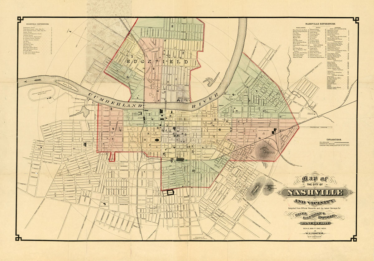
CAR-MAP-489
|
Map of Nashville, TN,
a reproduction of an 1879 map by Wilbur F. Foster.
A color version created from a copy at the Library
of Congress Archives; 36" w x 24" h.
|

|
$24
|
|
|
|
|
Catalog No.
|
Description
|
|
Price
|
|
CAR-MAP-154
|
Kentucky and Tennessee;
from a copy of Gray's Atlas; 1873. Created from an
original copy; 17" h x 22" w (slightly larger than
the original)
|

|
$15
|
|
|
|
|
Catalog No.
|
Description
|
|
Price
|
|
CAR-MAP-284
|
Kentucky & Tennessee;
Asher & Adams; 1873. Created from an original
copy; 24" x 16"
|

|
$20
|
|
|
|
|
Catalog No.
|
Description
|
|
Price
|
|
CAR-MAP-234
|
Map of Montgomery County, TN,
a reproduction of an 1877 map by D.G. Beers,
showing Civil Districts, cities and towns, land
owners, a business listing, and much more. A color
version created from a copy at the Library of
Congress Archives; 44" w x 58" h
|

|
$40
|
|
|
|
|
Catalog No.
|
Description
|
|
Price
|
|
CAR-MAP-502
|
Map of Madison County, TN,
a reproduction of an 1877 map by D.G. Beers,
showing Civil Districts, cities and towns, land
owners, a business listing, and much more. A color
version created from a copy at the Library of
Congress Archives; 36" w x 54" h
|

|
$40
|
|
|
|
|
Catalog No.
|
Description
|
|
Price
|
|
CAR-MAP-503
|
Map of Gibson County, TN,
a reproduction of an 1877 map by D.G. Beers,
showing Civil Districts, cities and towns, land
owners, a business listing, and much more. A color
version created from a copy at the Library of
Congress Archives; 41" w x 62" h
|

|
$40
|
|
|
|
|
Catalog No.
|
Description
|
|
Price
|
|
CAR-MAP-528
|
Map of Haywood County, TN,
a reproduction of an 1877 map by D.G. Beers,
showing Civil Districts, cities and towns, land
owners, a business listing, and much more. A color
version created from a copy at the Library of
Congress Archives; 38" w x 22" h
|

|
$25
|
|
|
|
|
Catalog No.
|
Description
|
|
Price
|
|
CAR-MAP-500
|
Map of Sumner, TN, a
reproduction of an 1878 map by D.G. Beers, showing
Civil Districts, cities and towns, land owners, a
business listing, and much more. A color version
created from a copy at the Library of Congress
Archives; 35" w x 51" h
|

|
$40
|
|
|
|
|
Catalog No.
|
Description
|
|
Price
|
|
CAR-MAP-111
|
Map of Bedford County, TN,
a reproduction of an 1878 map by D.G. Beers,
showing Civil Districts, cities and towns, land
owners, a business listing, and much more. A new
color version created from a copy at the Library
of Congress Archives; 33" w x 46" h
|

|
$30
|
|
|
|
|
Catalog No.
|
Description
|
|
Price
|
|
CAR-MAP-479
|
Map of Maury County, TN,
a reproduction of an 1878 map by D.G. Beers,
showing Civil Districts, cities and towns, land
owners, a business listing, and much more; 56" w x
37" h
|

|
$40
|
|
|
|
|
Catalog No.
|
Description
|
|
Price
|
|
CAR-MAP-233
|
Map of Rutherford County, TN,
a reproduction of an 1878 map by D.G. Beers,
showing Civil Districts, cities and towns, land
owners, a business listing, and much more. A color
version created from a copy at the Library of
Congress Archives; 44" w x 58" h
|

|
$40
|
|
|
|
|
Catalog No.
|
Description
|
|
Price
|
|
CAR-MAP-511
|
Map of Williamson County, TN,
a reproduction of an 1878 map by D.G. Beers,
showing Civil Districts, cities and towns, land
owners, a business listing, and much more. An
edited version created from images provided by the
Tennessee State Library and Archives; 46" w x 38"
h
Note: A 33x27 color version may also be
available from Rick Warwick; PO Box 71; Franklin, TN
37065. Proceeds of that version go to the Heritage
Foundation of Franklin & Williamson Co.; 510
Columbia Ave.; Franklin, TN 37064. Copies may also
be available from them.
|

|
$30
|
|
|
|
|
Catalog No.
|
Description
|
|
Price
|
|
CAR-MAP-571d
|
Map of Kentucky and Tennessee,
from the Rand McNally Business Atlas, 1879, a set
of the map and three index pages, from a copy at
the Library of Congress; each sheet 20" w x 14" h
|

|
$50
|
|
|
|
|
Catalog No.
|
Description
|
|
Price
|
|
CAR-MAP-571
|
Map of Kentucky and Tennessee,
from the Rand McNally Business Atlas, 1879, from a
copy at the Library of Congress; 20" w x 14" h
|
|
$15
|
|
|
|
|
Catalog No.
|
Description
|
|
Price
|
|
CAR-MAP-571a
|
Map of Kentucky and Tennessee,
from the Rand McNally Business Atlas, Index page
1, 1879, from a copy at the Library of Congress;
20" w x 14" h
|

|
$15
|
|
|
|
|
Catalog No.
|
Description
|
|
Price
|
|
CAR-MAP-571b
|
Map of Kentucky and Tennessee,
from the Rand McNally Business Atlas, Index page
2, 1879, from a copy at the Library of Congress;
20" w x 14" h
|

|
$15
|
|
|
|
|
Catalog No.
|
Description
|
|
Price
|
|
CAR-MAP-571c
|
Map of Kentucky and Tennessee,
from the Rand McNally Business Atlas, Index page
3, 1879, from a copy at the Library of Congress;
20" w x 14" h
|

|
$15
|
|
|
|
|
Catalog No.
|
Description
|
|
Price
|
|
CAR-MAP-112
|
Map of Bedford County, TN,
a reproduction of an 1835 Civil Districts map,
showing only the districts. A black and white
version created from a copy at the Tennessee State
Library and Archives, Nashville; 20" w x 14" h
|

|
$15
|
|
|
|
|
Catalog No.
|
Description
|
|
Price
|
|
CAR-MAP-113
|
Map of Bedford County, TN,
a reproduction of a Civil Districts map, date
unknown, showing the districts, cities and towns,
and other information. A black and white version
created from a copy at the Tennessee State Library
and Archives, Nashville; 26" w x 29" h
|

|
$24
|
|
|
|
|
Catalog No.
|
Description
|
|
Price
|
|
CAR-MAP-008
|
Map of the former territorial
limits of the Cherokee "Nation of Indians";
1884; drawn by C. C. Royce. Created from a print
at the Library of Congress Archives; approx. 36" h
x 36" w
|

|
$24
|
|
|
|
|
Catalog No.
|
Description
|
|
Price
|
|
CAR-MAP-543
|
Map of Knoxville;
1887; from the Knoxville City Directory. Created
from a print at the Tennessee State Library and
Archives; original approx. 25x29, printed 16x18
|

|
$15
|
|
|
|
|
Catalog No.
|
Description
|
|
Price
|
|
CAR-MAP-501
|
Map of Shelby
County, TN, a reproduction of an
1888 map by M.T. Williamson, showing Civil
Districts, cities and towns, land owners, a
business listing, and much more. A color version
slightly reduced in size from a copy at the
Library of Congress Archives; 42" w x 47" h
|

|
$40
|
|
|
|
|
Catalog No.
|
Description
|
|
Price
|
|
CAR-MAP-014
|
Tennessee, Railroad and
County Map, a large map showing
counties and cities; published by Rand, McNally
& Co., 1888; 18" h x 42" w
|

|
$24
|
|
|
|
|
Catalog No.
|
Description
|
|
Price
|
|
CAR-MAP-263
|
A Map of the City of
Chattanooga, Tennessee, G. M.
Hopkins., showing streets, businesses, etc., 1890;
21" h x 25" w
|

|
$20
|
|
|
|
|
Catalog No.
|
Description
|
|
Price
|
|
CAR-MAP-239
|
Map of Knoxville, 1890;
a reproduction of a Sanborn map at The Library of
Congress showing streets, businesses and other
items of interest, 21" x 25"
|

|
$20
|
|
|
|
|
Catalog No.
|
Description
|
|
Price
|
|
CAR-MAP-150
|
George Cram's Kentucky and
Tennessee; 1891. From one of his
atlases; 15" h. x 20" w, slightly larger than the
original
|

|
$15
|
|
|
|
|
Catalog No.
|
Description
|
|
Price
|
|
CAR-MAP-572
|
Harriman, Tennessee;
1892, J.P. Suverkrop; printed 31" wide by 16"
high, edited and reduced from the original at the
TSLA.
|

|
$20
|
|
|
|
|
Catalog No.
|
Description
|
|
Price
|
|
CAR-MAP-137
|
A City Map of Memphis,
Tennessee; from an original copy
published in Cram's Universal Atlas of the World,
1894; 14" h x 11" w
|

|
$8
|
|
|
|
|
Catalog No.
|
Description
|
|
Price
|
|
CAR-MAP-138
|
A City Map of Nashville,
Tennessee; from an original copy
published in Cram's Universal Atlas of the World,
1894; 14" h x 11" w
|

|
$8
|
|
|
|
|
Catalog No.
|
Description
|
|
Price
|
|
CAR-MAP-240
|
Map of Knoxville, 1895;
a reproduction of a Ogden Brothers map at The
Library of Congress showing streets and other
items of interest, 28" x 35"
|

|
$25
|
|
|
|
|
Catalog No.
|
Description
|
|
Price
|
|
CAR-MAP-171
|
1895 Knox County, Tennessee
Property Owners Map; a reproduction of
a map at The Library of Congress, which I paid
them to scan; 44" x 56" (slightly reduced from the
original). It shows property owners, churches,
schools, road, communities, cities and towns;
includes complete indexes of all features shown on
the map, one by district number and one sorted by
name
|

|
$30
|
|
|
|
|
Catalog No.
|
Description
|
|
Price
|
|
CAR-MAP-482
|
Lonsdale, Knox County,
Tennessee; a reproduction of a map
belonging to Wayne Keener, 36" x 28" date unknown,
but it looks as though it might have been the map
used to incorporate Lonsdale (now a part of
Knoxville).
|

|
$25
|
|
|
|
|
Catalog No.
|
Description
|
|
Price
|
|
CAR-MAP-527
|
Nashville, Tennessee;
Marshall & Bruce Co.; 1896; 26" x 25"; from a
copy at the Tennessee State Library and Archives
|

|
$20
|
|
|
|
|
Catalog No.
|
Description
|
|
Price
|
|
CAR-MAP-538
|
Nashville, Tennessee;
Matthews-Northrup; 1897; original size 11" x 9"
printed 16x20; from a copy at the Tennessee State
Library and Archives
|

|
$15
|
|
|
|
|
Catalog No.
|
Description
|
|
Price
|
|
CAR-MAP-163-54
|
Indian Cession Maps,
Created from original copies of the maps published
in the Eighteenth Annual Report of the Bureau of
Ethnology; 1897; 11" h x 17" w, although the size
varies depending on the map (see also CAR-MAP-008
above and -160 below). Sixty-seven different maps
are available, three of which relate to the
Cherokee. Thanks to Fred Smoot for these maps.
|
#54:

|
$8
|
|
|
|
|
Catalog No.
|
Description
|
|
Price
|
|
CAR-MAP-163-55
|
Indian Cession Maps,
Created from original copies of the maps published
in the Eighteenth Annual Report of the Bureau of
Ethnology; 1897; 11" h x 17" w, although the size
varies depending on the map (see also CAR-MAP-008
above and -160 below). Sixty-seven different maps
are available, three of which relate to the
Cherokee. Thanks to Fred Smoot for these maps.
|
#55:

|
$8
|
|
|
|
|
Catalog No.
|
Description
|
|
Price
|
|
CAR-MAP-163-56
|
Indian Cession Maps,
Created from original copies of the maps published
in the Eighteenth Annual Report of the Bureau of
Ethnology; 1897; 11" h x 17" w, although the size
varies depending on the map (see also CAR-MAP-008
above and -160 below). Sixty-seven different maps
are available, three of which relate to the
Cherokee. Thanks to Fred Smoot for these maps.
|
#56:

|
$8
|
|
|
|
|
Catalog No.
|
Description
|
|
Price
|
|
CAR-MAP-498
|
Map of Marshall County, TN,
a reproduction of an 1899 map by Rand-McNally,
showing Civil Districts, cities and towns, land
owners, a business listing, and much more. A color
version created from a copy at the Library of
Congress Archives; 32" w x 48" h
|

|
$40
|
|
|
|
|
Catalog No.
|
Description
|
|
Price
|
|
CAR-MAP-499
|
Map of Davidson County, TN,
a reproduction of an 1900 map by W.W. Southgate. A
version created from a poor blueprint copy at the
Library of Congress Archives; 32" w x 30" h
|

|
$25
|
|
|
|
|
Catalog No.
|
Description
|
|
Price
|
|
CAR-MAP-160
|
The Cherokee Country, Created
from
an original copy of a map published in the
Nineteenth Annual Report of the Bureau of
Ethnology; 1900; 11" h x 17" w (see also
CAR-MAP-008 and -163 elsewhere in this catalog).
|

|
$8
|
|
|
|
|
Catalog No.
|
Description
|
|
Price
|
|
CAR-MAP-536
|
Kentucky and Tennessee, early
1900s,
Waite & Co. 13x21
|

|
$15
|
|
|
|
|
Catalog No.
|
Description
|
|
Price
|
|
CAR-MAP-153
|
Tennessee; from The
New Century Atlas; 1897/1902. Created from an
original copy; 17" h x 22" w (slightly larger than
the original), one of the most attractive maps
produced in this era.
|

|
$15
|
|
|
|
|
Catalog No.
|
Description
|
|
Price
|
|
CAR-MAP-139
|
A Map of Kentucky and
Tennessee; from an original copy
published in the Twentieth Century Peerless Atlas
and Pictorial Gazetteer of All Lands, 1908; 10.5"
h x 13.5" w
|

|
$15
|
|
|
|
|
Catalog No.
|
Description
|
|
Price
|
|
CAR-MAP-241
|
Map of Knoxville, 1917;
a reproduction of a Sanborn map at The Library of
Congress showing streets and other items of
interest, 32" x 36"
|

|
$25
|
|
|
|
|
Catalog No.
|
Description
|
|
Price
|
|
CAR-MAP-540
|
Map of Davidson County, TN,
1920; author unknown, 30" x 34"; from
a map at the Tennessee State Library and Archives
|

|
$24
|
|
|
|
|
Catalog No.
|
Description
|
|
Price
|
|
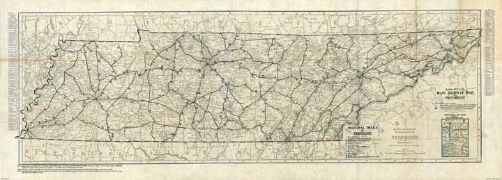
CAR-MAP-222a
|
Indexed and Pocket Map,
Tourists' and Shippers' Guide [of Tennessee]
- Roads. Published by Rand, McNally & Co.,
1920. Created from an original copy; 16" h x 45"
w.
|

|
$20
|
|
|
|
|
Catalog No.
|
Description
|
|
Price
|
|
CAR-MAP-222b
|
Indexed and Pocket Map,
Tourists' and Shippers' Guide [of Tennessee]
- Railroads. Published by Rand, McNally & Co.,
1920. Created from an original copy; 16" h x 45"
w.
|

|
$20
|
|
|
|
|
Catalog No.
|
Description
|
|
Price
|
|
CAR-MAP-177
|
An Archaeological Map of
Tennessee; from an original copy
published in the 42nd Annual Report of the Bureau
of Ethnology; 1924-25; includes an index; 11" h x
33" w.
|
Entire map

Click
here to see a small section of the map
|
$20
|
|
|
|
|
Catalog No.
|
Description
|
|
Price
|
|
CAR-MAP-497
|
Knoxville,
Tennessee; Nathan Nirenstein; 1929;
The Preferred
Business Real Estate Atlas of US Cities;
22" h by 30" w. Shows home and building details
of downtown Knoxville, including owner names.
Similar to the Sanborn fire insurance maps, but
w/o the insurance info.
|

|
$15.00
|
|
|
|
|
Catalog No.
|
Description
|
|
Price
|
|
CAR-MAP-298
|
Proposed Great Smoky
Mountains National Park; 1926; U.S.
Geological Survey Created from a print at the
Library of Congress Archives; approx. 23" h x 29"
w
|

|
$20
|
|
|
|
|
Catalog No.
|
Description
|
|
Price
|
|
CAR-MAP-541
|
Roane County, TN;
approx 1930; shows districts; Created from a print
at the Tennessee State Library and Archives; orig.
24" h x 33" printed 14x20
|

|
$15
|
|
|
|
|
Catalog No.
|
Description
|
|
Price
|
|
CAR-MAP-299
|
Preliminary Base Map, Great
Smoky Mountains National Park; 1934;
U.S. Park Service. Created from a print at the
Library of Congress Archives; approx. 26" h x 56"
w
|

|
$30
|
|
|
|
|
Catalog No.
|
Description
|
|
Price
|
|
CAR-MAP-488a
|
Great Smoky Mountains
National Park-Eastern Portion. USGS;
1934. Created from a print at the Library of
Congress Archives; 26x29
|

|
$20.00
|
|
|
|
|
Catalog No.
|
Description
|
|
Price
|
|
CAR-MAP-488b
|
Great Smoky Mountains National
Park-Western Portion. USGS; 1934.
Created from a print at the Library of Congress
Archives; 26x29 |

|
$20.00
|
|
|
|
|
Catalog No.
|
Description
|
|
Price
|
|
CAR-MAP-542
|
Smith County, TN TN Dept.
of Geology; 1937. Created from a print at the
Tennessee State Library and Archives; orig 37x26,
printed 14x20 |

|
$15.00
|
|
|
|
|
Catalog No.
|
Description
|
|
Price
|
|
CAR-MAP-539
|
Clay County, TN, TN Dept.
of Geology; 1938. Created from a print at the
Tennessee State Library and Archives; 33x22 |

|
$24.00
|
|
|
|
|
Catalog No.
|
Description
|
|
Price
|
|
CAR-MAP-312
|
A Map of Tennessee;
1939; Viking Press for the WPA; from an original
copy. Includes maps 312a, 312b, 312c, 312k, 312l
& 312m as described below.
|
|
$75
|
|
|
|
|
Catalog No.
|
Description
|
|
Price
|
|
CAR-MAP-312a
|
A Map of Tennessee;
1939; Viking Press for the WPA; from an original
copy.; approx. 16" h x 31" w
|

|
$20
|
|
|
|
|
Catalog No.
|
Description
|
|
Price
|
|
CAR-MAP-312b
|
A Map of Tennessee, Major
Cities; 1939; Viking Press for the
WPA; from an original copy.; approx. 16" h x 31" w
|

|
$20
|
|
|
|
|
Catalog No.
|
Description
|
|
Price
|
|
CAR-MAP-312c
|
A Map of Chattanooga;
(from map 312b+Downtown detail); 1939; Viking
Press for the WPA; from an original copy.; approx.
17" h x 19" w
|

|
$15
|
|
|
|
|
Catalog No.
|
Description
|
|
Price
|
|
CAR-MAP-312k
|
A Map of Knoxville;
(from map 312b+Downtown detail); 1939; Viking
Press for the WPA; from an original copy.; approx.
9" h x 21" w
|

|
$15
|
|
|
|
|
Catalog No.
|
Description
|
|
Price
|
|
CAR-MAP-312m
|
A Map of Memphis;
(from map 312b+Downtown detail); 1939; Viking
Press for the WPA; from an original copy.; approx.
13" h x 21" w
|

|
$15
|
|
|
|
|
Catalog No.
|
Description
|
|
Price
|
|
CAR-MAP-312n
|
A Map of Nashville;
(from map 312b+Downtown detail); 1939; Viking
Press for the WPA; from an original copy.; approx.
9" h x 21" w
|

|
$15
|
|
|
|
|
Catalog No.
|
Description
|
|
Price
|
|
CAR-MAP-581
|
A Map of Douglas Dam Cemetery
Relocation; map provided by Billie
McNamara; approx. 14" h x 32" w. A link will be
provided for a spreadsheet of the cemetery names,
etc.
|
 |
$24
|
|
|
|
|
Catalog No.
|
Description
|
|
Price
|
|
CAR-MAP-523
|
Clinton, Tennessee, a
map showing streets and a few landmarks as they
were in 1943; 10" h x 16" w; from an original
copy.
|

|
$8
|
|
|
|
|
Catalog No.
|
Description
|
|
Price
|
|
CAR-MAP-506
|
Oak Ridge, Tennessee,
a map showing streets and a few landmarks as they
were in 1946; 36" h x 15" w; from an original
copy.
|

|
$15
|
|
|
|
|
Catalog No.
|
Description
|
|
Price
|
|
CAR-MAP-105
|
Knoxville, Tennessee,
a map showing streets and a few landmarks as they
were in 1948; 21" h x 31" w; from an original copy
owned by Dr. J. C. (Jim) Tumblin.
|

|
$24
|
|
|
|
Return
to the Main Maps page
Return to
the ReevesMaps Home page.


